


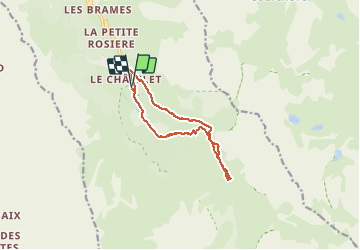
Meribel 10.3 km 20200810

cmike39
User

Length
10.8 km

Max alt
2033 m

Uphill gradient
403 m
Km-Effort
16.2 km

Min alt
1686 m

Downhill gradient
402 m
Boucle
Yes
Creation date :
2020-08-10 08:09:29.294
Updated on :
2020-08-10 12:57:53.405
3h01
Difficulty : Very easy

FREE GPS app for hiking
 SityTrail
IGN / Geographical institutes
SityTrail Plus
The world is yours!
About
Trail Walking of 10.8 km to be discovered at Auvergne-Rhône-Alpes, Savoy, Les Allues. This trail is proposed by cmike39.
Positioning
Country:
France
Region :
Auvergne-Rhône-Alpes
Department/Province :
Savoy
Municipality :
Les Allues
Location:
Unknown
Start:(Dec)
Start:(UTM)
310846 ; 5026656 (32T) N.
Comments